Eifel Trail
Hikers get close to nature in the Eifel National Park
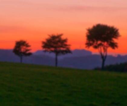
With trails, reservoirs, valleys and plateaus given over to nature, the Eifelsteig (Eifel Trail) is a paradise for hikers.
The motto of the Eifelsteig (Eifel Trail), which runs 313 kilometres from Aachen in North Rhine-Westphalia to Trier, is “Where rock and water accompany you”. In 15 stages, ranging in length from 14 to 29 kilometres, the Eifel Trail heads north to south through valleys, across plateaus, over hilltops and through dense forests. Its varied and natural route traverses unique natural areas, which in NRW include the moorland of the High Fens, the isolated Rur Valley and the mighty reservoirs of the North Eifel region. Continuing on and crossing the border into Rhineland-Palatinate, hikers pass the Vulkaneifel with the “eyes of the Eifel”, as the deep blue maars are known, as well as Gerolstein’s rugged dolomite cliffs. The Eifel Trail has been certified as a premium trail by the Deutsches Wanderinstitut e.V. (German Institute of Hiking).
One hiking highlight is without a doubt the Eifel National Park, which hikers soon reach in the sections nearest Aachen. In this national park, the only one in North Rhine-Westphalia, nature is allowed to develop freely: landscapes once shaped by human hands are gradually changing back into primordial beech forests. Covering an area of 110 km2 (equivalent to about 15,000 football pitches), its aim is to “let nature be nature”. Visitors can make exciting discoveries here all year round: every spring wild daffodils turn the meadows in the south of the national park into a sea of yellow; during the summer the meadows are characterised by fragrant wild herbs; on autumn rambles the call of red deer can be heard; and in the winter months tracks in the snow reveal the presence of wild cats, the shy “Eifel tigers”.
Linking up with the Eifelsteig are several partner hiking trails. While their quality matches that of the certified Eifelsteig trail, they cover much shorter distances. As such, most of them are ideal for day hikes, but hikers can also continue on to the Eifelsteig to extend their route by a couple of days. The Bächtaler Höhenroute (Upland Valleys Route), the Rur-Olef-Route, the Narzissenroute (Wild Daffodils Route) and the Burgenroute (Castles Route) are the names of just some of the partner trails, with new paths being added all the time.