Wanderin fotografiert die Landschaft, © Joschka Meiburg

Cicu­lar Hik­ing Trails in the Maas-Schwalm-Nette Nature Park

Wan­der­ing through a land­scape of streams and wa­ter mead­ows

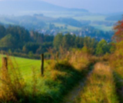
With its rivers, lakes and streams, the Maas-Schwalm-Nette Nature Park in the Lower Rhine is a wa­tery won­der­land for hikers.

The Lower Rhine region offers exceptional opportunities for hiking: nine circular routes in the Maas-Schwalm-Nette Nature Reserve, covering a total of around 100 kilometres, have been checked and certified by the Deutsches Wanderinstitut e.V. (German Institute of Hiking). The routes range from 6 to 19 kilometres in length and lead through forests and heathland, marshland, streams, water meadows, rivers, lakes and historic buildings – all typical features of the Lower Rhine region.

Hikers following the Zwei Seen Runde (Two Lakes Circuit) will discover the Borner See, a lake that appeared in the 17th century as the result of peat cutting, and other sights including the Born mill, which was mentioned in writing as early as 1412. The millers kept the mill running until 1960. A twilight trip through the primeval forests of Birgel offers hikers an opportunity to encounter nocturnal animals such as tawny owls, little owls and badgers. During the daytime, hawks, sparrowhawks, kites, wild boars, foxes and hares come out to play.

The Maas-Schwalm-Nette Nature Reserve is a particularly good place for hikers to enjoy day trips or short breaks. No other nature park is more shaped by water. The Maas, Schwalm and Nette rivers, which give the park its name, along with the River Niers and numerous lakes, streams and fen woods, all shape the nature reserve’s beautiful landscape.

 
Map of NRW

Tour overview

Info, data & tour route

Google Maps is rendered here. If Google Maps is accepted, data will be transfered to Google Maps.

Accept Google Maps
Distance in km
6
Duration in days
-
Walking/Journey time in hours
3

Highest point in metres
-
Uphill altitude difference
-
Downhill altitude difference
-
Tour Level
Level of difficulty
easy
  • Round trip
  • Family-friendly
  • Wheelchair-accessible

Images and videos

Be inspired: images of your NRW

Unterwegs am See, © Joschka Meiburg
Blick auf die Schwalm, © Joschka Meiburg
Naturpark Schwalm-Nette, © Joschka Meiburg
Wanderer unterwegs im Wald, © Joschka Meiburg
Wanderin fotografiert die Landschaft, © Joschka Meiburg

More information

Discover it now!

Would you like to make an enquiry?

Please contact »Naturpark Schwalm-Nette« directly


Your contact details

I have taken note of the data protection declaration of Tourismus NRW e.V. and agree that the data I have provided may be collected and stored electronically for the purpose of contacting me.

Security question *

* Please complete this field

More hik­ing trails in NRW

Bergisch Trail, © Das Bergische gGmbH

Ber­gisch Trail

Read more
wood figures at the Upland Trail, © Tourist-Information Willingen

Up­land Trail

Read more
In der Natur finden Wanderer interessante Pilze oder Pflanzen, © Foto Oliver Franke / Tourismus NRW e.V.

Wit­tgen­stein Slate Trail

Read more
Old tree at the Hermann Trail, © OWL Marketing GmbH,S. Westermann

Her­mann Trail

Read more
Kalvarienberg Alendorf, © Johannes Höhn

Eifel Trail

Read more
Rambler at the Viaduct Hiking Trail, © Gemeinde Altenbeken

Via­duct Hik­ing Trail

Read more
Canyon at the Teuto-Circuits hiking trails, © Rudolf Schubert

Teuto-Cir­cuits

Read more
Hikers at the Wilderness Trail, © G.Priske

Wil­der­ness Trail

Read more
Sauerland High-Flyer - the view at the range of mountains, © Sauerland Höhenflug

Sauer­land High-Fly­er

Read more
Kleine Dörfer liegen auf dem Weg, © Uwe Völkner - Fotoagentur FOX

Way of St. James

Read more
Roman Canal Hiking Trail - aqueduct Mechernich, © Natalie Glatter, Wandermagazin

Ro­man Canal Hik­ing Trail

Read more
Winterberg High-Altitude Trail, © Ferienwelt Winterberg

Win­ter­berg High-Alti­tude Trail

Read more
Olsberg Kneipp Hiking Trail, © Dominik Ketz

Ols­berg Kneipp Hik­ing Trail

Read more
The Veischede Sun Trail, © IG Veischedetal

Veischede Sun Trail

Read more
Rheinsteig hiking trail, © Tourismus NRW e.V.

Rhein­steig hik­ing trail

Read more
Extertal Burg Sternberg, © Gemeinde Extertal

Hanseat­ic Trail

Read more
The river at the Neanderland Steig trail, © Kreis Mettmann Martina Chardin

Nean­der­land Steig Trail

Read more
Kindelsbergpfad Fernblicke, © Natalie Glatter www.wandermagazin.de

Kindels­berg Trail

Read more
the landscape on Brilon Ridge Trail, © Brilon Wirtschaft und Tourismus GmbH

Bri­lon Ridge Trail

Read more
Skulpturenpfade im Kreis Mettmann Kunstwege, © Stadt Heiligenhaus

Trails of art in Nean­der­land

Read more
Sonnenuntergänge in der wie unberührt wirkenden Natur sind besonders beeindruckend, © Foto Oliver Franke / Tourismus NRW e.V.

Via Ad­rina – The “Pan­or­amic Path”

Read more
Blick vom Hermannsdenkmal, © Teutoburger Wald Tourismus - OWL GmbH

Her­mann Heights Trail

Read more
Wanderin fotografiert die Landschaft, © Joschka Meiburg

Cicu­lar Hik­ing Trails in the Maas-Schwalm-Nette Nature Park

Read more
Medebach Mountain Trail, © Touristik-Gesellschaft Medebach mbH

Medebach Moun­tain Trail

Read more
panoramic views at the Bestwig Panorama Trail, © Reinhard Schmidtmann

Bestwig Pan­or­ama Trail

Read more
break at the Ahrsteig, © www.ahrtal.de

Ahr­steig Trail

Read more
River Sieg Nature Trail, © RadRegionRheinland e.V.

River Sieg Nature Trail

Read more
Kleine Brücken führen den Bödefelder Hollenpfad über die Bäche, © Tourismus Schmallenberger Sauerland / K.-P. Kappest

Böde­feld­er Hol­len­pfad

Read more
fog at the Ehmsen trail, © Julian Stratenschulte

Ehm­sen Trail

Read more
two people enjoy the scenery at the Egge trail, © Teutoburger Wald Tourismus

Egge Trail

Read more
Blick über die Landschaft - Rothaarsteig-Spuren, © Rothaarsteigverein e.V. Klaus-Peter Kappest

Rothaarsteig-tracks

Read more
Der Landweg ist einer der Bergischen Streifzüge, © Das Bergische GmbH

Ber­gisch Wan­der­ings

Read more
Upper Sauerland Ridge Trail, © Ferienwelt Winterberg

Up­per Sauer­land Ridge Trail

Read more
Kupferroute Bank an der Gedenkstätte, © Birgit Engelen

Cop­per Trail

Read more
Die Usseler Heide ist Teil des Rundwegs, © Sauerland Höhenflug

Düd­ing­hausen Geo­lo­gic­al Trail

Read more
nrw-aktiv_radfahren_mg_0779_e

Ruhrhöhen­weg

Read more
Hängebrücke bei Kühhude am Rothaarsteig, © Rothaarsteigverein e.V. Björn Hänssler

Rothaar Trail

Read more