Hängebrücke bei Kühhude am Rothaarsteig, © Rothaarsteigverein e.V. Björn Hänssler

Rothaar Trail

For nature lov­ers and ad­ven­ture hikers

One of Europe’s most beau­ti­ful high-alti­tude trails scores highly with its 154 kilo­metres, the Kyrill-Pfad (Kyrill Trail) and the an­nu­al mara­thon.

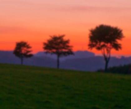
The Rothaar Trail is the flagship hiking trail of Sauerland and the Siegerland-Wittgenstein region, and is considered one of the most beautiful high-altitude trails in Europe. This “path of the senses”, which runs for 154 kilometres along a wide variety of natural trails, paths and forest tracks, begins in Brilon in NRW and ends in Dillenburg in Hesse. Curved forest sofas and benches to rest on, picnic tables, original shelters and forest loungers “furnish” the Rothaar Trail. As well as numerous viewpoints, the path also runs past a variety of destinations with natural history, cultural or historic interest. The trail has been awarded the “Qualitätsweg Wanderbares Deutschland” seal of quality by the German Hiking Association (DWV).

One feature is the Kyrill-Pfad (Kyrill Trail), which was constructed close to Schmallenberg-Schanze by the Rothaar Trail rangers to serve as a reminder of the severe windstorms of January 2007. This 1,000-metre path was built among the windfall, with bridges and ladders allowing visitors to reach uprooted and fallen trees. A 40-metre hanging bridge over a small wooded ravine near the little village of Kühhude offers an informative insight into the forest ecosystem. The Rothaar Trail rangers also offer hikers advice and practical support, and can provide comprehensive information on paths, the forest and the region. Adventure hikes guided by the rangers are also available.

Once a year, nature fans also head over the Rothaar Trail in double-quick time, swapping hiking boots for soft soles: the scenic Rothaar Trail Marathon attracts runners, walkers and Nordic walkers from all over Germany and has developed into a real fun run with a place in the national marathon calendar.

Map of NRW

Tour overview

Info, data & tour route

Google Maps is rendered here. If Google Maps is accepted, data will be transfered to Google Maps.

Accept Google Maps
Distance in km
154
Duration in days
-
Walking/Journey time in hours
97

Highest point in metres
831
Uphill altitude difference
2,878
Downhill altitude difference
3,108
Tour Level
Level of difficulty
intermediate
  • Round trip
  • Family-friendly
  • Wheelchair-accessible

Images and videos

Be inspired: images of your NRW

More information

Discover it now!

Would you like to make an enquiry?

Please contact »Rothaarsteigverein e.V.« directly


Your contact details

I have taken note of the data protection declaration of Tourismus NRW e.V. and agree that the data I have provided may be collected and stored electronically for the purpose of contacting me.

Security question *

* Please complete this field

More hik­ing trails in NRW

Bergisch Trail, © Das Bergische gGmbH

Ber­gisch Trail

Read more
wood figures at the Upland Trail, © Tourist-Information Willingen

Up­land Trail

Read more
In der Natur finden Wanderer interessante Pilze oder Pflanzen, © Foto Oliver Franke / Tourismus NRW e.V.

Wit­tgen­stein Slate Trail

Read more
Old tree at the Hermann Trail, © OWL Marketing GmbH,S. Westermann

Her­mann Trail

Read more
Kalvarienberg Alendorf, © Johannes Höhn

Eifel Trail

Read more
Rambler at the Viaduct Hiking Trail, © Gemeinde Altenbeken

Via­duct Hik­ing Trail

Read more
Canyon at the Teuto-Circuits hiking trails, © Rudolf Schubert

Teuto-Cir­cuits

Read more
Hikers at the Wilderness Trail, © G.Priske

Wil­der­ness Trail

Read more
Sauerland High-Flyer - the view at the range of mountains, © Sauerland Höhenflug

Sauer­land High-Fly­er

Read more
Kleine Dörfer liegen auf dem Weg, © Uwe Völkner - Fotoagentur FOX

Way of St. James

Read more
Roman Canal Hiking Trail - aqueduct Mechernich, © Natalie Glatter, Wandermagazin

Ro­man Canal Hik­ing Trail

Read more
Winterberg High-Altitude Trail, © Ferienwelt Winterberg

Win­ter­berg High-Alti­tude Trail

Read more
Olsberg Kneipp Hiking Trail, © Dominik Ketz

Ols­berg Kneipp Hik­ing Trail

Read more
The Veischede Sun Trail, © IG Veischedetal

Veischede Sun Trail

Read more
Rheinsteig hiking trail, © Tourismus NRW e.V.

Rhein­steig hik­ing trail

Read more
Extertal Burg Sternberg, © Gemeinde Extertal

Hanseat­ic Trail

Read more
The river at the Neanderland Steig trail, © Kreis Mettmann Martina Chardin

Nean­der­land Steig Trail

Read more
Kindelsbergpfad Fernblicke, © Natalie Glatter www.wandermagazin.de

Kindels­berg Trail

Read more
the landscape on Brilon Ridge Trail, © Brilon Wirtschaft und Tourismus GmbH

Bri­lon Ridge Trail

Read more
Skulpturenpfade im Kreis Mettmann Kunstwege, © Stadt Heiligenhaus

Trails of art in Nean­der­land

Read more
Sonnenuntergänge in der wie unberührt wirkenden Natur sind besonders beeindruckend, © Foto Oliver Franke / Tourismus NRW e.V.

Via Ad­rina – The “Pan­or­amic Path”

Read more
Blick vom Hermannsdenkmal, © Teutoburger Wald Tourismus - OWL GmbH

Her­mann Heights Trail

Read more
Wanderin fotografiert die Landschaft, © Joschka Meiburg

Cicu­lar Hik­ing Trails in the Maas-Schwalm-Nette Nature Park

Read more
Medebach Mountain Trail, © Touristik-Gesellschaft Medebach mbH

Medebach Moun­tain Trail

Read more
panoramic views at the Bestwig Panorama Trail, © Reinhard Schmidtmann

Bestwig Pan­or­ama Trail

Read more
break at the Ahrsteig, © www.ahrtal.de

Ahr­steig Trail

Read more
River Sieg Nature Trail, © RadRegionRheinland e.V.

River Sieg Nature Trail

Read more
Kleine Brücken führen den Bödefelder Hollenpfad über die Bäche, © Tourismus Schmallenberger Sauerland / K.-P. Kappest

Böde­feld­er Hol­len­pfad

Read more
fog at the Ehmsen trail, © Julian Stratenschulte

Ehm­sen Trail

Read more
two people enjoy the scenery at the Egge trail, © Teutoburger Wald Tourismus

Egge Trail

Read more
Blick über die Landschaft - Rothaarsteig-Spuren, © Rothaarsteigverein e.V. Klaus-Peter Kappest

Rothaarsteig-tracks

Read more
Der Landweg ist einer der Bergischen Streifzüge, © Das Bergische GmbH

Ber­gisch Wan­der­ings

Read more
Upper Sauerland Ridge Trail, © Ferienwelt Winterberg

Up­per Sauer­land Ridge Trail

Read more
Kupferroute Bank an der Gedenkstätte, © Birgit Engelen

Cop­per Trail

Read more
Die Usseler Heide ist Teil des Rundwegs, © Sauerland Höhenflug

Düd­ing­hausen Geo­lo­gic­al Trail

Read more
nrw-aktiv_radfahren_mg_0779_e

Ruhrhöhen­weg

Read more
Hängebrücke bei Kühhude am Rothaarsteig, © Rothaarsteigverein e.V. Björn Hänssler

Rothaar Trail

Read more