Weiher in Blankenheim, © Eifel Tourismus, Dominik Ketz

Ahr cycle route

Act­ive travel between the Eifel and Rhine re­gions

The Ahr cycle route winds its way over 80 kilo­metres through one of the most beau­ti­ful vine­yard re­gions in the coun­try, and is a good des­tin­a­tion for a sporty day trip with a a re­lax­ing glass of wine to fin­ish the tour.

After the floods in mid-July 2021, the cycle path is partially passable on the sections Blankenheim to Fuchshofen and Bad Neuenahr-Ahrweiler to Sinzig with detours. More info on this under: www.ahrtal.de

The starting point is already the first attraction. At the source of the Ahr river, which bubbles out under a half-timbered building in the historic town centre of Blankenheim, cyclists start their tour through the Eifel through to the confluence of the river with the Rhine at Sinzig. Over short or longer stages, the route never leaves the water, through a unique natural and cultural landscape, with vineyards, forests, imposing panoramas, small historic towns, bridges and viaducts.

There is no need to worry about challenging uphill climbs. The maximum ascent is an altitude of just 150 meters. Otherwise, the Ahr cycle route travels over disused railway tracks and asphalted cycle and field tracks. For this reason, it is also suitable for families with children and less well-trained cyclists planning a day trip or a short holiday in the romantic Ahr valley.

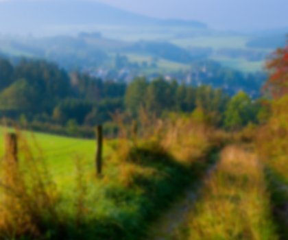
It is certainly worth stopping along the way to take in the views. One of these is the “Eifelblick Kalvarienberg” (Eifel view from Calvary hill) near Alendorf. Here visitors can enjoy not only unusual views onto the Eifel mountains and the Dollendorf limestone riverbed. The verdant juniper vegetation and more than 30 types of orchid, gentian, autumn crocuses and numerous kinds of butterfly which live in the Lampertstal nature conservation area attract local residents and visitors to the area to the Kalvarienberg hill every year.

Cyclists will need to bring enough water with them to quench their thirst. However, a glass of wine is naturally also an option, with a relaxing end to the day in one of the traditional taverns and wineries along the way.

www.ahrtal.de

Map of NRW

Tour overview

Info, data & tour route

Google Maps is rendered here. If Google Maps is accepted, data will be transfered to Google Maps.

Accept Google Maps
Distance in km
75
Duration in days
-
Walking/Journey time in hours
6

Highest point in metres
468
Uphill altitude difference
463
Downhill altitude difference
869
Tour Level
Level of difficulty
-
  • Round trip
  • Family-friendly
  • Wheelchair-accessible

Images and videos

Be inspired: images of your NRW

Wanderer an Ahr-Quelle in Blankenheim, © Dominik Ketz
Fahrradtour durch die Weinberge im Ahrtal, © Ahrtal Tourismus Bad Neuenahr Ahrweiler e.V.
Fahrradfahrer im Herbst im Ahrtal, © Ahrtal Tourismus Bad Neuenahr Ahrweiler e.V.
Hahnensteiner Mühle, © Tourist-Info HocheifelNürburgring
An der Ahrquelle in Blankenheim, © Eifel Tourismus Dominik Ketz
Burg Blankenheim nah, © Eifel Tourismus Dominik Ketz
Eifelmuseum Blankenheim, © Eifel Tourismus Dominik Ketz
Weiher in Blankenheim, © Eifel Tourismus Dominik Ketz

More information

Discover it now!

Would you like to make an enquiry?

Please contact »Ahrtal-Tourismus Bad Neuenahr-Ahrweiler e.V« directly


Your contact details

I have taken note of the data protection declaration of Tourismus NRW e.V. and agree that the data I have provided may be collected and stored electronically for the purpose of contacting me.

Security question *

* Please complete this field

Dis­cov­er more Cycle Routes

Die flachen Wege auf alten Bahntrassen machen die Balkantrasse zu einer gemütlichen Radstrecke, © Volker Barthel

Balkan­trasse Cycle Path

Read more
Waterfront break at the Möhnetal, © Sauerland Tourismus Stratmann

Möhne Val­ley Cycle Path

Read more
Die Vennbahn, ein Bahntrassenradweg, führt auch übers Reichensteiner Viadukt, © vennbahn.eu

Ven­n­bahn Cycle Route

Read more
Idyllische Parks bieten sich auf dem Töddenland-Radweg für Pausen an, © Stadtmarketing Ibbenbüren GmbH

Töd­den­land Cycle Path

Read more
Der Oelchenshammer, der zum LVR-Industriemuseum Kraftwerk Ermen & Engels gehört, ist die letzte wasserbetriebene Schmiede im Oberbergischen Land., © LVR Industriemuseum

In­dus­tri­al her­it­age in the Rhine­land with a bi­cycle

Read more
River Weser Cycle Path, © Peter Hübbe

Weser Cycle Path

Read more
Cyclists on tour at Lahn Valley Cycle Path, © Touristikverband Siegerland-Wittgenstein e.V

Lahn Val­ley Cycle Path

Read more
Die Grenzgängerroute verläuft durch das Münsterland und den Teutoburger Wald, © Tourismusverband Osnabrücker Land e.V.

Teuto-Ems bor­der route

Read more
Eine Fähre bringt die Radfahrer auf die andere Seite der Lippe, © Lippefähre Dorsten

Ro­man Lippe Route

Read more
The Oberhausen Gasometer is in close proximity to the Westfield Centro, the Ludwig Gallery at Schloss Oberhausen and the Rhine-Herne Canal, © Gasometer Oberhausen, Dirk Böttger

Cyc­ling the Route der In­dus­triekul­tur (In­dus­tri­al Her­it­age Trail)

Read more
Die Paderborner-Land-Route führt an prächtigen Schlössern vorbei, © Touristikzentrale Paderborner Land e.V.

Pader­borner Land Route Cycle Path

Read more
Discover the castle Linnep in Ratingen by bike, © KME M.Chardin

Dis­cov­er Rat­in­gen by bike

Read more
Relaxed cycling in Münsterland, © Oliver Franke, Tourismus NRW e.V

Re­laxed cyc­ling in Mün­ster­land

Read more
Auf dem Erft-Radweg ist das Wasser ein stetiger Begleiter, © Rhein-Erft Tourismus e.V.

The Erft cycle route

Read more
Die Flusslandschaft Achterhoeck-Westmünsterland bietet malerische Ausblicke, © Grenzerlebnisse

Achter­hoek and West­mün­ster­land river land­scapes

Read more
nrw-aktiv_radfahren_mg_0779_e_3

Wa­ter castles route

Read more
Radeln entlang des Emsradweges, © Münsterland e.V.

River Ems Cycle Path

Read more
Aussicht Ruhrtalradweg, © RuhrtalRadweg, Dennis Stratmann

Ruhr Val­ley Cycle Path

Read more
Monastery Gardens Route - family is taking a break, © I. Jansen, Kulturland Kreis Höxter

Mon­as­tery Gar­dens Route

Read more
Fahrradtour durchs Grüne im Ahrtal, © Ahrtal Tourismus Bad Neuenahr Ahrweiler e.V.

Ahr cycle route

Read more
Am Niederrhein bieten sich Promenaden zu gemütlichen Radtouren an, © Niederrhein Tourismus GmbH

Rhine Cycle Route

Read more
Eifel Peak Route Cycle Path - old building, © Dominik Ketz

Eifel Peak Route Cycle Path

Read more
Burg Blankenberg, © RadRegionRheinland

Siegtal cycle route

Read more
Three Rivers Tour cycle path at the rhine, © Rhein-Erft Tourismus e.V.

Three Rivers Tour

Read more
Aggertalsperre im Bergischen, © Maren Pussak Das Bergische

Ber­gis­cher Pan­or­ama cycle route

Read more
Bruchertalsperre, © Tourismus NRW e.V.

Wa­ter Quin­tet Cycle Path

Read more
Biggeblick am Biggesee, © Tourismus NRW e.V.

Ruhr-Sieg Cycle Path

Read more
Schloss Corvey in Höxter, © Kulturkreis Hoexter-Corvey gGmbH

Euroroute R1 cycle path

Read more
An der Niederrheinroute gibt es zahlreiche Windmühlen, © Pixabay

Lower Rhine Route cycle path

Read more
River Eder Floodplains Cycle Path - grand tour, © Reiner Schild

River Eder Cycle Path

Read more
Panorama bike path crossing on wagon bridge, © Stadt Heiligenhaus

Nieder­ber­g­bahn Pan­or­ama Cycle Track

Read more
Burg Hülshoff in Havixbeck, © Münsterland e.V.

100-Castles-Route

Read more
family on tour at the Sauerland Cycle Circuit, © Sauerland-Tourismus e.V Foto Stromberg

Sauer­land Cycle Cir­cuit

Read more
Der Vechtetalradweg verläuft immer an der Vechte entlang, © Grafschaft Bentheim Tourismus e.V.

Vec­htet­al route

Read more
Blick auf die Niers, © Kreis Viersen

River Niers Cycle Path

Read more