Olsberg Kneipp Hiking Trail, © Dominik Ketz

Ols­berg Kneipp Hik­ing Trail

Cool your feet in clear streams
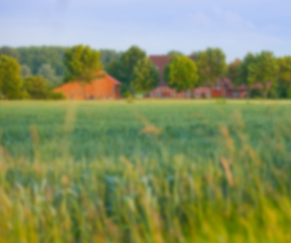
En­joy both the beau­ti­ful land­scape of Sauer­land and health be­ne­fits on the Ols­berg Kneipp hik­ing trail.

Hiking the Olsberger Kneippwanderweg (Olsberg Kneipp Hiking Trail) means combining a wonderful adventure in the Sauerland countryside with the Kneipp health philosophy of water treading. This approximately 40-kilometre trail heads around the Kneipp location of Olsberg through a watery landscape. A total of six treading spots (primarily in shallow streams) allow hikers to enjoy Kneipp hydrotherapy treatment until the end of October; for those who aren’t interested in Kneipp therapy, the route is accessible all year round.

If desired, hikers can seek help from Kneipp trail guides. Experts trained in Kneipp medicine will accompany you, demonstrate cold water applications and explain their effects. Guests will also be offered lots of interesting information about Olsberg, its culture and history, and its flora and fauna.

Castles among the trail highlights

Sights along the way include the castles Schloss Schellenstein and Schloss Gevelinghausen with the historic Gevelinghauser Mühle mill. Hikers can make a prior appointment to see the mill’s museum of local history or fortify themselves at the castle’s restaurant. The panoramic view from Olsberg, which is more than 700 metres high, is the crowning glory of the circular hiking trail.

The Philippstollen exhibition mine is worth a short detour; here visitors travel almost 600 metres underground on a discovery tour. Iron ore was mined here as early as pre-Christian times. The mine was decommissioned in 1916. Visitors can take tours in groups of eight or more.

By the way: you won’t need a towel for the Kneipp Hiking Trail, as according to Dr Kneipp, feet that have been cooled by water treading should dry in the open air.

The Olsberg Kneipp Hiking Trail has received the “Qualitätsweg Wanderbares Deutschland” seal of quality from the German Hiking Association (DWV) and its consistent thematic focus is unique in Germany.

Map of NRW

Tour overview

Info, data & tour route

Google Maps is rendered here. If Google Maps is accepted, data will be transfered to Google Maps.

Accept Google Maps
Distance in km
43
Duration in days
-
Walking/Journey time in hours
-

Highest point in metres
725
Uphill altitude difference
1,550
Downhill altitude difference
1,550
Tour Level
Level of difficulty
hard
  • Round trip
  • Family-friendly
  • Wheelchair-accessible

More information

Discover it now!

Would you like to make an enquiry?

Please contact »Tourismus Brilon Olsberg GmbH« directly


Your contact details

I have taken note of the data protection declaration of Tourismus NRW e.V. and agree that the data I have provided may be collected and stored electronically for the purpose of contacting me.

Security question *

* Please complete this field

More hik­ing trails in NRW

Roman Canal Hiking Trail - aqueduct Mechernich, © Natalie Glatter, Wandermagazin

Ro­man Canal Hik­ing Trail

Read more
Kleine Brücken führen den Bödefelder Hollenpfad über die Bäche, © Tourismus Schmallenberger Sauerland / K.-P. Kappest

Böde­feld­er Hol­len­pfad

Read more
Old tree at the Hermann Trail, © OWL Marketing GmbH,S. Westermann

Her­mann Trail

Read more
Kleine Dörfer liegen auf dem Weg, © Uwe Völkner - Fotoagentur FOX

Way of St. James

Read more
panoramic views at the Bestwig Panorama Trail, © Reinhard Schmidtmann

Bestwig Pan­or­ama Trail

Read more
Wanderin fotografiert die Landschaft, © Joschka Meiburg

Cicu­lar Hik­ing Trails in the Maas-Schwalm-Nette Nature Park

Read more
Rambler at the Viaduct Hiking Trail, © Gemeinde Altenbeken

Via­duct Hik­ing Trail

Read more
Die Usseler Heide ist Teil des Rundwegs, © Sauerland Höhenflug

Düd­ing­hausen Geo­lo­gic­al Trail

Read more
break at the Ahrsteig, © www.ahrtal.de

Ahr­steig Trail

Read more
Sauerland High-Flyer - the view at the range of mountains, © Sauerland Höhenflug

Sauer­land High-Fly­er

Read more
Hikers at the Wilderness Trail, © G.Priske

Wil­der­ness Trail

Read more
Hängebrücke bei Kühhude am Rothaarsteig, © Rothaarsteigverein e.V. Björn Hänssler

Rothaar Trail

Read more
Skulpturenpfade im Kreis Mettmann Kunstwege, © Stadt Heiligenhaus

Trails of art in Nean­der­land

Read more
the landscape on Brilon Ridge Trail, © Brilon Wirtschaft und Tourismus GmbH

Bri­lon Ridge Trail

Read more
Medebach Mountain Trail, © Touristik-Gesellschaft Medebach mbH

Medebach Moun­tain Trail

Read more
Sonnenuntergänge in der wie unberührt wirkenden Natur sind besonders beeindruckend, © Foto Oliver Franke / Tourismus NRW e.V.

Via Ad­rina – The “Pan­or­amic Path”

Read more
Blick über die Landschaft - Rothaarsteig-Spuren, © Rothaarsteigverein e.V. Klaus-Peter Kappest

Rothaarsteig-tracks

Read more
Blick vom Hermannsdenkmal, © Teutoburger Wald Tourismus - OWL GmbH

Her­mann Heights Trail

Read more
Kalvarienberg Alendorf, © Johannes Höhn

Eifel Trail

Read more
Olsberg Kneipp Hiking Trail, © Dominik Ketz

Ols­berg Kneipp Hik­ing Trail

Read more
fog at the Ehmsen trail, © Julian Stratenschulte

Ehm­sen Trail

Read more
two people enjoy the scenery at the Egge trail, © Teutoburger Wald Tourismus

Egge Trail

Read more
Canyon at the Teuto-Circuits hiking trails, © Rudolf Schubert

Teuto-Cir­cuits

Read more
nrw-aktiv_radfahren_mg_0779_e

Ruhrhöhen­weg

Read more
The river at the Neanderland Steig trail, © Kreis Mettmann Martina Chardin

Nean­der­land Steig Trail

Read more
Kindelsbergpfad Fernblicke, © Natalie Glatter www.wandermagazin.de

Kindels­berg Trail

Read more
Bergisch Trail, © Das Bergische gGmbH

Ber­gisch Trail

Read more
Rheinsteig hiking trail, © Tourismus NRW e.V.

Rhein­steig hik­ing trail

Read more
In der Natur finden Wanderer interessante Pilze oder Pflanzen, © Foto Oliver Franke / Tourismus NRW e.V.

Wit­tgen­stein Slate Trail

Read more
wood figures at the Upland Trail, © Tourist-Information Willingen

Up­land Trail

Read more
The Veischede Sun Trail, © IG Veischedetal

Veischede Sun Trail

Read more
River Sieg Nature Trail, © RadRegionRheinland e.V.

River Sieg Nature Trail

Read more
Winterberg High-Altitude Trail, © Ferienwelt Winterberg

Win­ter­berg High-Alti­tude Trail

Read more
Der Landweg ist einer der Bergischen Streifzüge, © Das Bergische GmbH

Ber­gisch Wan­der­ings

Read more
Extertal Burg Sternberg, © Gemeinde Extertal

Hanseat­ic Trail

Read more
Kupferroute Bank an der Gedenkstätte, © Birgit Engelen

Cop­per Trail

Read more
Upper Sauerland Ridge Trail, © Ferienwelt Winterberg

Up­per Sauer­land Ridge Trail

Read more